upper waypoint

Map: Earthquake Shake Zones Around the U.S.

Save ArticleSave Article
Failed to save article

Please try again

Researchers with the U.S. Geological Survey have refined their understanding of how soft basins of sedimentary rock below Earth’s surface amplify shaking from big earthquakes. The San Francisco Bay Area, Los Angeles, Seattle and Salt Lake City all have deep basins beneath them.

The study gives policymakers more detailed information to assess the strength of buildings during a major earthquake, and to guide homeowners in reinforcing their houses. The new estimates will be included in future building codes. The data has also been incorporated into the USGS hazard map that was released last week, and which you can see below.

Among the findings: a 25% increase in potential shaking for Walnut Creek and a 10% increase for San Jose over the last USGS hazard assessment in 2014.

Click on the map to see a larger version.
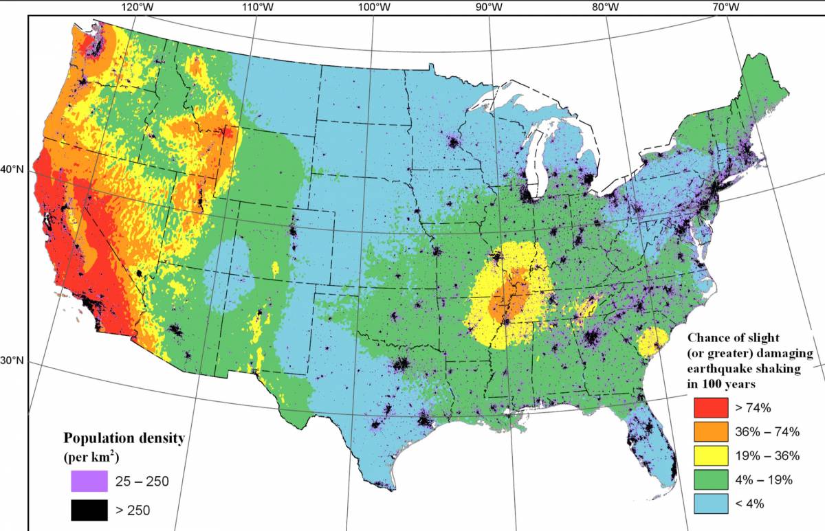
Map showing the chance of damaging earthquake shaking within 100 years. (USGS)

“We looked at these core areas to try and estimate how we can better account for these shaking levels beneath urban areas across the western U.S.,” said Mark Petersen, a research geologist with the USGS, who presented the study at the American Geophysical Union’s annual fall conference in San Francisco last week.

Sponsored

The research on soft basins has been incorporated into the latest USGS earthquake assessment, which reports the potential for a large quake on the San Andreas and Cascadia faults remains high across the West Coast.

Already, the Building Seismic Safety Council, an organization that provides guidance to the building industry on earthquake safety issues, voted to use the new models in its 2020 guidelines, the San Jose Mercury News reported.

Shaking Like Jelly

Geologists have long known that these basins increase the shaking in earthquakes of long duration. The basins form underground in places where rocks are warped into bowl-like shapes by tectonic stress.

Underground streams pass through the bowls and fill them with “soft sediments that can shake like a bowl filled with jelly, amplifying the shaking,” said Peterson. “Many times these deep basins overlay urban areas.”

The new shaking data is now a part  of a USGS hazard model, which incorporates data on past earthquakes to help forecast where and how often future temblors will occur, their magnitude, and the intensity of the ground’s shaking. The models are based on where previous earthquakes have struck and the data obtained by geologists who study faults.

Policymakers and city officials incorporate the models into codes for buildings, bridges, roads and railways; the insurance industry uses them to assess risk;and they inform seismic stability studies of dams, power plants, schools and hospitals.

Peterson says the models influence $1 trillion worth of construction and insurance costs annually in the U.S.

lower waypoint
next waypoint
Sick Brown Pelicans Are Turning Up Along the Coast — and We Don't Know WhySee How the Northern Lights Lit Up the Bay Area This WeekendThe Bay Area Butterfly Festival Is Happening This Weekend in VallejoCalifornia Regulators Approve Adding Fixed Charge of Up to $24 to Utility BillsClimate Voters Grapple With Ethical Dilemma in California's District 13 RaceNewsom Seeks Faster Track for Home Insurance Rate Hikes as Market ShrinksCalifornia’s New 1600-Acre State Park Set to Open This SummerThe Never-ending Battle Over Martins Beach ExplainedCalifornia's Second-Largest Reservoir Filled to CapacityEverything You Never Wanted to Know About Snail Sex