Egypt
Presidential republic
Official:
Arab Republic of Egypt
Local name:
مصر Miṣr
Region:
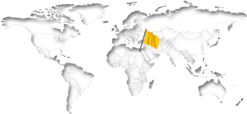
Northern Africa
Surface area:
1,001,450 km²
Capital:
Cairo
Geography
Egypt is a country in Northeast Africa directly at the Mediterranean Sea and the Sinai Peninsula. The land has a total area of 1,001,450 km² (386,662 mi²) and a total coastline of 2,450 km (1,522.4 mi). This land area is approximately 144% of the area of Texas. Egypt is thus one of the largest countries in Africa and the 30th biggest in the world. Only slightly less than half of all residents (43%) live within cities.Egypt is comparatively low at an average elevation of 321 meters above sea level. The highest mountain peak (Dschabal Katrina) is at 2,637 meters. The country has about 30 islands. There are direct national borders with the four neighboring countries Palestine, Israel, Libya and Sudan. The distance between New York City and the Capital Cairo is about 9,030 km (5,611 mi).
On further pages:
Current time in Egypt:
The countrywide time in Egypt is Eastern European Time (EET), which is currently 7 hours ahead of New York.
As in many countries far away from the equator, there is a daylight savings time in the summer. Related to GMT, the time difference is usually +2 hours in summer and +3 hours in winter. The next time change will be on October 31 at 11:00 pm (local time).
Time zones and clock changesSunrise + Sunset00:00
May 2024
The countrywide time in Egypt is Eastern European Time (EET), which is currently 7 hours ahead of New York.
As in many countries far away from the equator, there is a daylight savings time in the summer. Related to GMT, the time difference is usually +2 hours in summer and +3 hours in winter. The next time change will be on October 31 at 11:00 pm (local time).
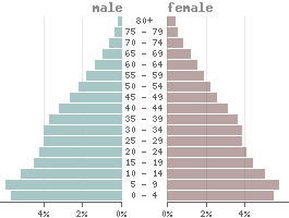
Population
Population:110,990,000
Population per km²:110.8
Life expectancy males:Ø 67.9 years
Life expectancy females:
Ø 72.6 yearsBirth rate:
22.6 ‰Death rate:
6.3 ‰Males/Females:
50.6% : 49.4%Population pyramid
The currency in Egypt is the Egypt pound (EGP).
1 Pound is divided into 100 Piasters.
Status: 05/02/2024
1 Pound is divided into 100 Piasters.
Status: 05/02/2024
1 US dollar = 48.06 Pounds
1000 Pounds = 20.81 US dollar
1000 Pounds = 20.81 US dollar
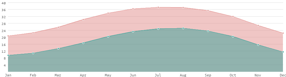
Climate in Egypt
In Egypt, a subtropical climate predominates with clear regional differences. The coastal areas along the Mediterranean have a Mediterranean climate with mild, humid winters and hot, dry summers. Inland, including the Nile Valley and the Delta, has a hot desert climate with hot summers and mild winters. The western and eastern deserts of the Sahara have very dry desert climates with extremely hot daytime temperatures and cooler nights. There is a little rainfall only in the winter months.Average daytime and nighttime temperatures
Languages
Official language:
Arabic
| Mother tongue | Distribution |
|---|---|
| Arabic | 98.8 % |
| Nubian | 0.7 % |
| Domari | 0.2 % |
| other | 0.3 % |
Religions
State religion:
Sunni Islam
| Religion | Distribution |
|---|---|
| Copts | 8.0% |
| other Christs | 1.7% |
| Muslims | 90.0% |
| other | 0.3% |
more...
Economy
| GDP: | 476.75 bn $ |
| Exportations: | 76.30 bn $ |
| Importations: | 97.14 bn $ |
| › Tourism receipts: | 9.50 bn $ |
| Debt rate: | 88.53 % |
| › Unemployment rate: | 6.96 % |
| › Inflation rate: | 13.90 % |
| › Corruption index: | 35 (bad) |
| › Energy consumption: | 149.1 bn kWh |
According to the definition from the International Monetary Fund (IMF), Egypt is a developing country because of its lower economic performance.
With an average annual income of 4,100 USD Egypt is one of the lower middle-income countries.
Land use
| 2% Urban areas: | 24,270 km² |
| 4% Agricultural areas: | 38,456 km² |
| 0% Forest: | 501 km² |
| 1% Water areas: | 6,000 km² |
| 94% Others: | 938,223 km² |
more...
Transport
| Roadways: | 65,050 km |
| Railways: | 7,024 km |
| Waterways: | 3,500 km |
| Reg. vehicles: | 7,195,355 |
| › Airports: |
Most important cities
Population refers to the city proper, not metropolitan areas.
| City | Region | Population |
|---|---|---|
| Cairo / Capital | Nile Delta | 10,045,000 |
| Alexandria | Nile Delta | 5,442,000 |
| Giza | Western Desert | 4,367,000 |
| Luxor | Nile Valley | 1,333,000 |
| Port Said | Nile Delta | 571,000 |
| Asyut | Nile Valley | 529,000 |
| Helwan | Nile Delta | 521,000 |
| Suez | Eastern Desert / Red Sea | 512,000 |
| Edfu | Nile Valley | 489,000 |
| Al Mansurah | Nile Delta | 439,000 |
| Talkha | Nile Delta | 414,000 |
| Tanda | Nile Delta | 405,000 |
| Al Fayyum | Nile Valley | 316,000 |
| Zagazig | Nile Delta | 303,000 |
| Ismailia | Nile Delta | 293,000 |
| Minya | Nile Valley | 284,000 |
| Beni Suef | Nile Valley | 273,000 |
| Shibin El Kom | Nile Delta | 268,000 |
| Aswan | Nile Valley | 266,000 |
| Qina | Nile Valley | 253,000 |
| Damanhur | Nile Delta | 244,000 |
| Damietta | Nile Delta | 207,000 |
| Arish | Sinai Peninsula | 199,000 |
| Sohag | Nile Valley | 190,000 |
| Kafr El Sheikh | Nile Delta | 187,000 |
| Banha | Nile Delta | 158,000 |
The difference between the urban area and the city proper alone can be considerable. Cairo, for example, has an urban population of 20,296,000. However, the actual proper city is much smaller with only 10,045,000 inhabitants. The difference to metropolitan regions, i.e. conurbations with several cities, is even greater.
Political indicators
(Based on the "Worldwide Governance Indicators" project of the World Bank)
| Political stability: | ◈ |
| Rule of law: | ◈ |
| Effectivity: | ◈ |
| Regulatory quality: | ◈ |
| Voice accountability: | ◈ |
| Autocracy Index: | ◈ |
| Death penalty: | Legally allowed |
Existing trade agreements
- CENSAD - Community of Sahel-Saharan States
- COMESA - Common Market for Eastern and Southern Africa
- GAFTA - Greater Arab Free Trade Area
- OAPEC - Organization of Arab Petroleum Exporting Countries
 Country comparison: Egypt / India
 Israel: country data and statistics
 List of 152 developing countries